Mexico City: traces of an island capital
By Cities to get lost in · myAudience
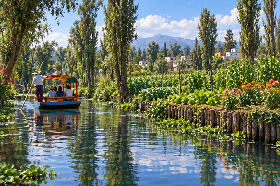
myAudience · original AI-generated landscape illustration · Original generated illustration; no documentary accuracy, current-condition or exact-viewpoint claim
Mexico City’s historic centre occupies the site of Tenochtitlan, the Mexica capital built within the lake landscape of the Valley of Mexico. Spanish conquest destroyed much of that city, and the colonial capital developed over its remains while the surrounding waters were progressively transformed.
The resulting city contains pre-Hispanic archaeological evidence, colonial buildings and later public architecture in the same urban setting. Indigenous artisans and workers also contributed to the colonial city. Its material history cannot be explained as the work of just one society.
Xochimilco preserves another part of the basin’s story through canals and chinampas. Although often called floating gardens, these agricultural plots are constructed land within a water-based system, not gardens freely drifting around a lake. Their productivity depends on knowledge, labour and environmental conditions.
The World Heritage property links the historic centre with this agricultural landscape. Urban development, water extraction and pollution create pressures on the surviving system. A street scene and a canal scene may look like different worlds, yet both help explain how a modern capital emerged from, and continues to interact with, a former lake environment.
Image: illustration, not a documentary photograph.
Further reading
Mexico City's lake history makes a familiar idea about urban ground less straightforward. Ground can be constructed, reclaimed, maintained and reorganised rather than simply found ready for building. Tenochtitlan grew within a lake setting, and the historic centre inherited aspects of that earlier urban arrangement after conquest. The UNESCO account connects the later city's streets and public spaces with the pre-existing network. This does not make every colonial building an Indigenous design, or erase the violence of conquest. It means that the new capital developed through an existing landscape and the labour of people who understood it. Water, routes and construction can therefore be read together, rather than placing an entirely disconnected city over a vanished past.
The Templo Mayor gives that history a specific archaeological focus. INAH describes its dual dedication to Tláloc and Huitzilopochtli and the sequence of enlargements through which later building covered earlier phases. The two dedications connected rain and agriculture with another set of political and religious concerns, rather than presenting a single undifferentiated sacred space. Accounts of the temple's place at the centre of a cosmic order should be understood as beliefs within Mexica religion, not as a literal geographical discovery. The distinction allows the beliefs to be taken seriously on their own terms. A building could make ideas about authority and the world tangible through paired sanctuaries, approaches and public ritual. Its surviving fabric helps scholars investigate those relationships.
Layered construction also changes the way evidence is read. Enlarging a building around an earlier version can preserve material that would otherwise have remained exposed, while making it difficult to see several phases at once. Archaeological work must separate those phases rather than treating every visible stone as part of one final design. INAH's account of the 1978 discovery of the Coyolxauhqui monolith and the subsequent project illustrates how work within a present city can open new knowledge of an earlier one. Discovery is not the same as instant interpretation. Objects, architectural relationships and their recorded locations need to be studied together. The result is a changing account built from evidence, not simply a reconstruction produced from a dramatic find.
Xochimilco preserves a different relationship between land, water and human work. Chinampas are raised agricultural plots within a wetland system, not freely drifting platforms. FAO describes their construction from material including sediment, branches and decaying vegetation, arranged as strips separated by channels. The plot provides a cultivated surface while the surrounding water remains part of the system. This is an important distinction: building a field does not necessarily require removing water from the entire landscape. Instead, the useful relationship is between raised ground and channels beside it. The resulting pattern can serve growing, movement and the management of a working wetland. The term often translated as floating gardens should not obscure that physical arrangement.
The field edge is part of the design. FAO identifies rows of ahuejote willows around chinampa plots, alongside channels and ditches, and describes continuing inputs of organic material to cultivated soils. A field is therefore more than the visible crops on top. Its boundary, the condition of the surrounding water and the material returned to the soil all affect how it works over time. That makes the system a useful introduction to agriculture as the management of relationships. Growing and harvesting remove material; maintaining fertility requires further work and inputs. Different crops and rotations add another layer of decisions. A picturesque channel alone cannot communicate this continuing labour, even when it is the part most easily photographed.
FAO also describes changes from maize-centred production towards a wider range of crops serving the urban market. That history is a reminder that traditional knowledge does not mean unchanging practice. Farmers respond to customers, conditions and the needs of their households while drawing on inherited skills. A system can remain recognisable through those changes because the relationships between plots, channels, vegetation and labour persist. Its value is not limited to being old. It continues to connect food production with the city around it. At the same time, a general description of the heritage system cannot establish the quality of water or the condition of every individual plot today. Those are local questions requiring direct evidence.
The image offers a way to begin noticing the arrangement without turning it into a claim about a named farm. Compare the planted raised edge with the open channel and the route taken by the boat. The field and the water provide different working surfaces, while the willows create a taller boundary. That contrast helps explain why the landscape should be read as a connected system. It also connects Xochimilco back to the wider history of Mexico City: settlement, cultivation and movement have repeatedly depended on how water and ground were arranged. The city is much more than the inheritance of one civilisation or one period. Its educational appeal lies in seeing how successive communities adapted an extraordinary setting, and how living knowledge continues within it.