The warm-ocean engine of a tropical cyclone
By UK GCSE Geography · independent study · myAudience
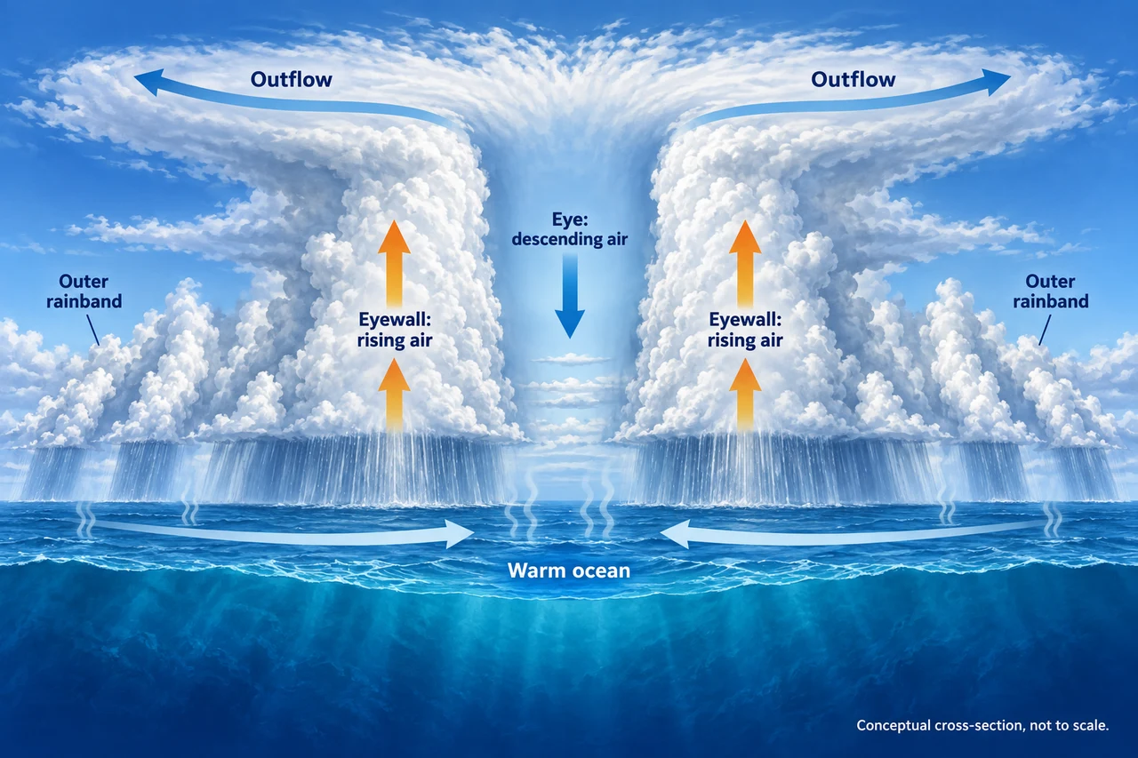
Image: illustration, not a documentary photograph. Original teaching model created for myAudience. · Original generated teaching illustration; no source textbook artwork reproduced.
The warm-ocean engine of a tropical cyclone
A tropical cyclone is an organized rotating storm powered by heat and moisture from a warm ocean. Hurricane, typhoon and cyclone are regional names for the same broad type of system. Formation usually needs sufficiently warm water through a useful depth, moist air, an existing disturbance and limited vertical wind shear. Warm water alone is not enough. Rotation is weak close to the Equator, which helps explain why these storms generally form some distance from it.
Evaporation supplies water vapour. As moist air rises and condenses, latent heat is released, helping sustain vigorous ascent. Air converges at low levels and flows outward high above the storm. In a developed cyclone, the eyewall contains strong rising motion and hazardous winds and rain; air in the eye often descends. The eye can be calmer, but its passage does not mean the danger is over: another eyewall can follow.
Across the illustration, trace surface inflow, eyewall ascent, upper outflow and eye descent. It is a vertical cross-section, so it does not show the storm’s spiral rotation. Ocean heat can sustain a storm; land, cooler water or disruptive wind shear can weaken its circulation. A weakening cyclone can still cause dangerous rain and flooding. Wind-based intensity labels do not describe every impact.
A warming climate can increase cyclone-associated rainfall and the proportion of very intense storms, but that does not justify saying that all basins must have more storms every year. IPCC assessments distinguish intensity, frequency, regional differences and confidence. The hazards reaching people also depend on the track, speed, tides, relief and exposure. Keep these separate when interpreting a dramatic headline.
Worked example: A fictional forecast lowers maximum winds from 130 to 100 km/h while forecasting 250 mm of rain. Can the lower wind estimate alone show that flood risk is lower?
The wind estimate measures one part of the hazard.
Rainfall, catchment conditions, drainage and exposure determine flooding.
No comparable rainfall or river forecast for the earlier scenario is provided.
Answer: No; the stated data do not establish a reduction in flood risk.
Check your understanding: Why should someone not interpret the arrival of a calm eye as the end of a cyclone?
Answer: The opposite eyewall can bring renewed hazardous conditions.
Why: The eye is part of the storm structure, not evidence that the whole system has passed. Follow official local warnings rather than this conceptual diagram as real-time advice.