Summer 2027 historic environment: Hastings as an argument
By UK GCSE History · independent study · myAudience
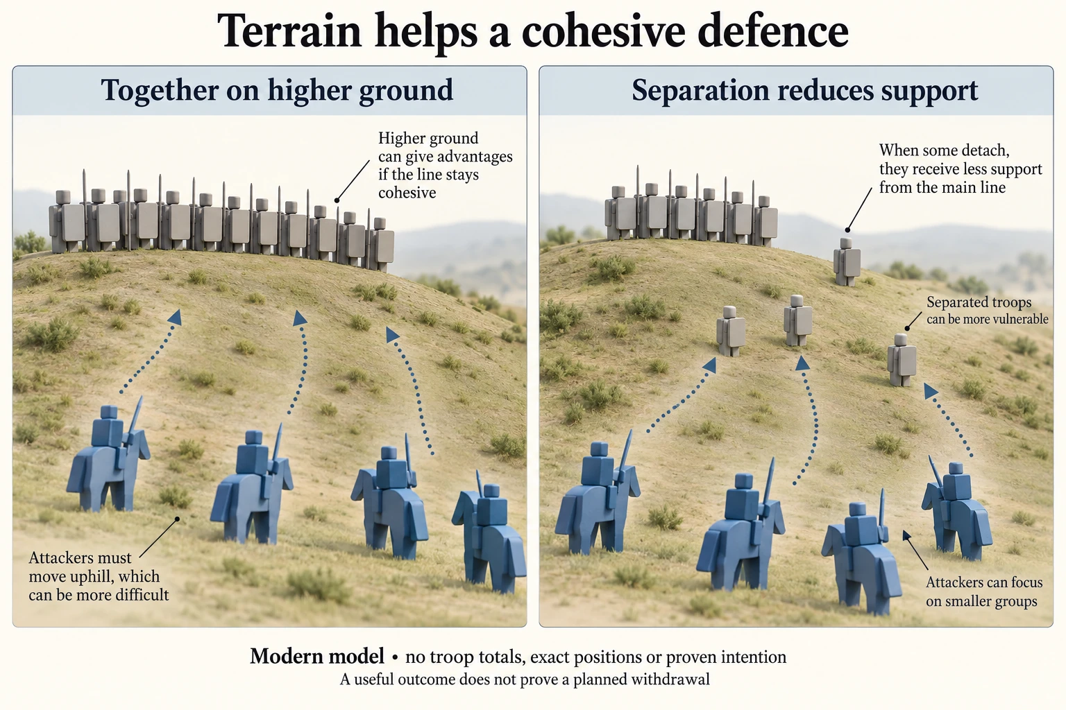
Original built-in imagegen teaching model; author inspected 2026-10-04. Not documentary evidence. Prepared immutable candidate WebP and 160/640 variants. · Isolated pending review only. Publication rights and integration acceptance remain for root review; no third-party source graphic copied.
Summer 2027 historic environment: Hastings as an argument
This lesson selects the Battle of Hastings for the summer 2027 Norman England historic-environment requirement. This is an assessment-year choice, not a permanent substitute for the site in every series. The location must be understood in relation to events and wider developments. English Heritage distinguishes the battlefield from the later abbey occupying part of the landscape. Later commemoration is evidence of remembering a battle; it is not a photograph of the fighting or proof of every tactical detail.
An environment argument connects a feature to a mechanism and then to a consequence. A ridge could support a defensive position; cohesion could exploit that position; a breakdown in cohesion could change the battle; victory could open the way to a change of rule. Each link has a different evidential burden. Observing a slope today cannot establish a particular command in 1066, and a plausible command cannot itself explain all the later changes in government.
The plate shows the positional mechanism clearly while deliberately omitting a measured scale, exact bearings and troop totals. Its second panel proposes vulnerability after pursuit. State this limit when using it: a modern illustration can help a reader understand an argument supported elsewhere, but it cannot corroborate that argument independently. Historians also distinguish the site's wartime use from later building and memorial use. A landscape is not frozen at the date selected by an exam.
A sustained argument needs a criterion of importance. If the question asks why the battlefield shaped the outcome, compare terrain with tactics and leadership through their effects on fighting. If it asks about consequences, connect the result with contested kingship and subsequent consolidation. Avoid a memorised tour of features that never answers the question. More detailed topographic, archaeological and source review remains necessary before this short initial treatment can claim full historic-environment depth.
The public site notice was rechecked on 4 October 2026: BA Norman England uses Hastings for summer 2027, while Pevensey and the White Tower belong to different listed assessment years. This is cohort evidence, not evidence about the battle. In a site argument, distinguish the date of an event, the date of surviving fabric and the assessment series. A later abbey can support an enquiry into commemoration without locating every soldier. Today's contours require interpretation alongside dated evidence; a visitor's viewpoint does not establish a medieval command or precise line of movement.
Constructed interpretation A argues that the environment constrained the fighting; B argues that human decisions made the environment consequential. The scope is the relation between place and events at Hastings, not an all-purpose judgement on Norman government. A defended ridge supports A's explanation of opportunities; reported changes in cohesion and attack would support B's explanation of how those opportunities were used. Their difference is causal emphasis, not necessarily factual contradiction. The strength of a site response comes from connecting features to a mechanism appropriate to the question, while acknowledging uncertainty about exact episodes and later landscape changes.
A source-to-argument paragraph can begin with a feature, but must end with the enquiry. For causation, explain how a ridge could favour a close defence, then how maintaining or losing cohesion affected its usefulness. For consequences, the ridge alone is insufficient: the argument must move through the battle's result to altered capacity to claim and enforce kingship. That longer chain needs additional evidence for each transition. Do not treat the site as a self-contained cause of every later policy. Nor should a modern teaching image acquire evidential status merely because it is visually coherent or labelled with the correct assessment year.
Demanding transfer, constructed: a present-day aerial image shows a substantial later building where a class diagram places a defended line. A learner claims the building proves the diagram's troop positions. Model answer: the sources answer different questions. The aerial image records present fabric; dating and archaeological context are needed to relate that fabric to 1066. The diagram proposes a mechanism without exact survey coordinates. Neither alone corroborates troop positions. A better argument identifies the ridge's possible military role through contextual evidence and separates that from later commemoration. This answer concerns evidence use, not a claim that the present landscape has no historical value.
Worked example: Original extended argument: 'The defensive position mattered more than any decision during the battle.' Develop a judgement with a counterargument.
Define importance as explanatory contribution to opportunities and the eventual outcome.
Argue that higher ground favoured a cohesive foot-soldier defence; this explains why the position was valuable.
Counter that physical advantage had to be maintained through cohesion, and opportunities created by separation depended on actions. Reject a sharp separation between place and decisions.
Additional original evaluated transfer model (7, part 1/4): The aerial image does not prove the diagram's troop positions, because it records a later built landscape while the diagram presents a modern explanatory model. For the summer 2027 BA Norman route, the selected environment is the Battle of Hastings, not the 2026 Pevensey site. The relevant criterion is whether a feature can be securely connected to the event and the particular question. Present fabric can reveal later uses and preservation, but an apparent overlap on an image cannot by itself establish where a defended line stood in 1066.
Additional original evaluated transfer model (7, part 2/4): Dating is the first necessary distinction. A later abbey may commemorate the battle and affect what survives, while its walls or footprint need not reproduce earlier deployments. Construction phases, archaeological context and securely identified landscape features would help connect present observations to the period. The generic classroom slope contains no surveyed coordinates, so its line cannot serve as independent corroboration for the photograph. Both images may be useful, but they are useful for different enquiries. Treating their visual resemblance as confirmation would use a modern model to authenticate the assumptions from which that model was made.
Additional original evaluated transfer model (7, part 3/4): There is still an argument for the military relevance of the ridge. Institutional historical accounts describe the defended position and uphill assaults, while acknowledging uncertainty about details and the battlefield's precise extent. A cohesive position on higher ground supplies a plausible mechanism for mutual support and difficulty faced by attackers. This bounded contextual claim is stronger than exact troop-location claims drawn from a later building. In a consequences enquiry, even the mechanism is insufficient alone: the answer must trace what the result changed in kingship, authority and subsequent control, rather than merely describe a feature.
Additional original evaluated transfer model (7, part 4/4): My judgement is that the aerial image can guide questions about the site's later history, preservation and setting, while dated contextual evidence is needed to evaluate its connection to 1066. The diagram helps explain a military possibility, not certify a deployment. A strong answer would identify which claim each source supports, state the remaining spatial uncertainty and relate the feature to wider events. That approach avoids both dismissing the present landscape as historically worthless and assuming every surviving structure records the battle. It also keeps site study tied to causation or consequences instead of substituting a descriptive list for an argument.
Answer: The position was an important enabling condition because it favoured a defended line, but it did not determine the result. Decisions and cohesion affected whether that advantage endured and whether attackers could exploit changes. Thus the statement overstates an independent effect of terrain. Exact tactical episodes require critical comparison of accounts.
Check your understanding: 1 Which year and option does this site serve? 2 Why is a later abbey not direct evidence of troop positions? 3 Transfer: explain why the same feature might be central to a causation answer but insufficient in a consequences answer.
Answer: Summer 2027, study strand Section B BA Norman England. An abbey reflects later building and commemoration rather than necessarily preserving exact deployments. A ridge helps explain fighting conditions, but a consequences answer must trace how the result affected kingship and control. The feature becomes relevant through a causal link suited to the question; listing it is insufficient.
Why: This prevents year mixing and descriptive feature lists. It corrects the misconception that historic environment means only buildings or that a site essay can ignore wider history. The model offers an argued position without pretending to reproduce an exam question or award an official mark.