1. Think in systems: boundaries, stores and conservation
By UK A Level Geography · independent study · myAudience
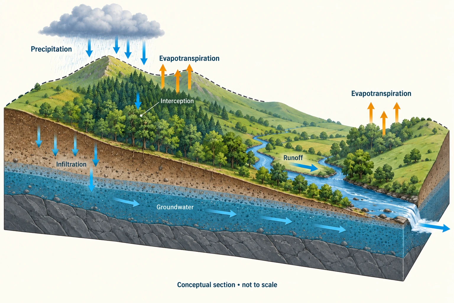
Image: illustration, not a documentary photograph. · Original generated teaching artwork; provenance retained. No, government or research-body endorsement.
1. Think in systems: boundaries, stores and conservation
A geographical system is a set of interacting components studied within a declared boundary. The boundary is a decision in the investigation, not necessarily a visible wall. A drainage divide separates surface runoff toward different outlets, but groundwater can cross it where geology allows. An open basin exchanges water and energy with its surroundings. Global water is approximately a closed material system over classroom timescales, while Earth exchanges energy with space. Calling the planet closed does not mean its oceans, atmosphere and land are individually closed. Always specify substance, spatial boundary and observation interval before assigning an input or output.
A store is an amount present at an instant, expressed in units such as cubic metres of water or tonnes of carbon. A flux is an amount transferred per unit time. Rainfall depth accumulated over one day is neither the instantaneous atmospheric store nor a discharge in cubic metres per second. Multiply depth by area to obtain volume, then divide by the matching time interval if a mean rate is needed. In the basin plate, the soil and aquifer retain water while arrows describe transfers. The drawing is conceptual and not to scale; arrow thickness is not a measurement of relative flux. Water below the ground is generally in pores and fractures, not in a universal underground lake.
For a defined interval, change in storage equals total inputs minus total outputs. Internal transfers cancel when the whole system is considered: infiltration leaves a surface store and enters a soil store. It is therefore not an additional loss from the basin. If precipitation is 100 units, outlet runoff is 40 and evapotranspiration is 30, the residual is a storage increase of 30, provided cross-boundary groundwater and abstraction are negligible. A negative change means depletion of an existing store, not negative physical water. This simple accounting is a demanding test of explanations because every proposed extra output needs a source.
Dynamic equilibrium means that stores fluctuate around a broadly stable condition while transfers continue. A steady water level can conceal large equal inflows and outflows. It does not establish that the same molecules remain inside. Nor does a two-day average balance establish seasonal equilibrium. A basin may store winter precipitation and release it in summer; a glacier can lose mass over decades despite gaining snow each winter. Choosing an interval that omits recovery can make a reversible storm response look like permanent change. Choosing one that averages over a persistent trend can hide it.
Feedback requires a causal return pathway. A larger store producing a larger outlet flux can oppose the original increase, creating stabilising feedback. A dry soil state that suppresses plant cover, reduces infiltration and promotes further drying can amplify disturbance under some conditions. Positive and negative describe amplification and damping, not moral value. A chain from rainfall to runoff alone is a response, not a feedback loop. To test a proposed loop, identify the disturbed variable, follow every causal link, return to that variable and ask whether the returning effect reinforces or opposes the initial change.
A system explanation should name its omissions. A storm balance residual could be real soil recharge, an unmeasured transfer, rainfall sampling bias or inconsistent clocks. Conservation still applies; the measurement model may be incomplete. Compare competing interpretations by seeking an independent observation, such as repeated groundwater levels, rather than labelling every unexplained residual 'storage'. This is the first habit of the course: use a model to make a prediction, test it against evidence, and retain a bounded conclusion. The original numerical examples are teaching simulations authored on 4 October 2026, not field observations or claims about a real country.
Worked example: Original simulation: a fictional basin initially contains 80,000 m³. Over 12 hours precipitation adds 30,000 m³; evapotranspiration removes 2,000 m³; the river outlet removes 16,000 m³; groundwater crosses inward by 3,000 m³ and pumping exports 5,000 m³. An internal infiltration estimate is 9,000 m³. Find final storage and explain whether excluding groundwater reverses the sign.
Evaluated extension (original task): Evaluate whether the calculated water-store change proves sustainable management.
Use only transfers crossing the stated basin boundary: inputs = 30,000 + 3,000 = 33,000 m³.
Outputs = 2,000 + 16,000 + 5,000 = 23,000 m³. The internal infiltration estimate is not an extra output.
Storage change = 10,000 m³; final storage = 90,000 m³. Excluding groundwater gives +7,000 m³, still positive but biased low.
A level observation must be converted to storage using basin geometry before it can corroborate 10,000 m³.
A final water store of 90,000 m³, a 10,000 m³ increase, is evidence of accumulation within the specified basin and interval, but it does not establish sustainable management. That judgment concerns whether supply and environmental functions can persist across relevant timescales without unacceptable losses elsewhere. The accounting includes 80,000 m³ initially, 30,000 m³ precipitation and 3,000 m³ groundwater inflow, then subtracts 2,000 m³ evapotranspiration, 16,000 m³ river-outlet flow and 5,000 m³ pumping. The resulting final store is 90,000 m³: the gain is 10,000 m³, not 90,000 m³. Internal infiltration changes the location of water without adding water to the whole-basin account.
Excluding groundwater exchange changes the apparent final store to 87,000 m³, because the declared cross-boundary groundwater contribution is 3,000 m³. Such a difference need not imply that one calculation violates conservation; the investigator may have measured different spatial boundaries or omitted a flux. An aquifer boundary following geological connectivity could include neighbouring recharge areas that a surface drainage divide excludes. That expanded boundary changes which transfers count as internal, yet does not allow an internal transfer to be counted twice as a new input. This is why a drawn watershed cannot settle the groundwater budget alone.
A positive balance in a wet interval also says little about a dry season. A system can have a stable long-term stock while experiencing large, continuing inputs and outputs; conversely, a short-lived surplus may accompany falling groundwater levels in a particular part of the catchment. Pumping may reduce baseflow or wetland supply even while another store gains water. The evidence therefore needs both spatially distributed storage observations and repeated budgets, with uncertainty estimates. Independent water-level or soil-moisture measurements can test whether the residual reflects actual accumulation rather than a biased precipitation estimate or an unmeasured abstraction.
I would accept the narrower conclusion that the declared central-value budget implies a 10,000 m³ net gain during this interval. I would reject the stronger sustainability claim until demand, water quality, ecological-flow requirements and repeated recharge conditions were examined. Where users or ecosystems depend on a depleted sub-store, a whole-basin gain is inadequate protection. Where several independently measured seasons show recharge balancing withdrawals without damaging flows or quality, the case for sustainable management becomes stronger. The decision thus depends on the chosen boundary, timescale and distribution of benefits, rather than the sign of one residual alone.
Answer: Final storage is 90,000 m³ under the declared boundary. The sign survives omitting groundwater in this example, but the magnitude does not. Conservation does not prove that every transfer estimate is correct.
Check your understanding: Transfer: choose a boundary around the aquifer alone. Is infiltration still internal? Explain why a constant aquifer level does not demonstrate that pumping is sustainable.
Answer: Infiltration crossing from soil into the aquifer becomes an aquifer input. Constant level suggests balanced storage only if the level–storage relationship is stable; it can coexist with pumping supplied by reduced river discharge or cross-boundary inflow. Sustainability also depends on ecological flow, water quality and future recharge.
Why: Changing the boundary changes the classification of a transfer, not conservation. A stable state is a balance observation; it is not evidence that all connected users and ecosystems retain their previous supply.